1. The Importance of Trail Markings in American Hiking
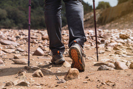
When hiking in the United States, trail markings play a crucial role in keeping you safe and on the right path. Whether you’re exploring a national park or a local forest preserve, understanding these signs can make all the difference between a fun adventure and getting lost. Trail markings, also called “blazes,” are used to guide hikers, indicate direction changes, and warn about difficult terrain. They help prevent confusion at trail intersections and ensure you stay on designated paths that are maintained and safe.
Common Scenarios Where Trail Markings Matter
Hikers in America often encounter a variety of situations where knowing how to read trail markings is essential:
| Scenario | How Trail Markings Help |
|---|---|
| Trail Intersections | Blazes or signposts show which way to go when trails split or cross. |
| Unclear Paths | Markers keep you on track when the route isn’t obvious due to overgrowth or rocks. |
| Changing Terrain | Different colors or shapes may signal tougher sections ahead or warn of hazards. |
| Long-Distance Hikes | Consistent blazes help you follow the same trail over many miles, reducing risk of getting lost. |
| Poor Weather Conditions | Visible markers help navigation when fog, rain, or snow obscure natural landmarks. |
Types of Trail Markings You’ll See in the U.S.
The most common types of trail markings include painted blazes on trees or rocks, colored plastic tags, cairns (piles of stones), and wooden signposts. Here’s a quick overview:
| Type of Marking | Description |
|---|---|
| Pained Blaze (Rectangle) | A colored rectangle painted on trees or rocks; white blazes mark the Appalachian Trail. |
| Cairn | A stack of rocks used especially above tree line where painting isn’t possible. |
| Plastic Tag or Ribbon | Tied around branches; used for temporary routes or races. |
| Signpost/Arrow Sign | Wooden or metal posts at junctions with arrows showing direction and distances. |
The Bottom Line: Safety First with Trail Markings
No matter your experience level, paying attention to trail markings is one of the best ways to stay safe while hiking in America. Always start your hike by learning what the local markings mean—they’re your best guide out there!
2. Common Types of Trail Markings and Their Meanings
Trail Blazes
Blazes are one of the most common trail markers in the United States. They are usually painted or nailed onto trees, rocks, or posts. The color and pattern tell you which trail you’re on and can help you stay on the right path.
| Blaze Color | Meaning |
|---|---|
| White | Often marks major trails (e.g., Appalachian Trail) |
| Blue | Side trails or connecting routes |
| Yellow/Red/Other Colors | Designate specific trails; check local maps for details |
Cairns
Cairns are stacks of rocks that guide hikers, especially above tree line or where blazes aren’t practical. In American parks, cairns are carefully placed by rangers or experienced hikers. If you see a cairn, follow its direction but avoid building new ones to prevent confusion.
Trail Signs
Trail signs in U.S. parks and forests provide important information such as trail names, directions, distances, and sometimes elevation gain. These signs are often found at trailheads, junctions, or major waypoints.
What to Look For:
- Trail Name and Number: Matches what’s on your map.
- Mileage: Helps estimate your hiking time.
- Direction Arrows: Point you toward the correct path.
Colored Stakes and Posts
Colored stakes or posts may be used in open areas like prairies, deserts, or meadows where trees are scarce. The color codes usually correspond to different trails or difficulty levels. Always check the trailhead map for a color legend before starting your hike.
Symbols and Icons
Parks across America use symbols to convey quick information:
| Symbol/Icon | What It Means |
|---|---|
| Hiking trail starts here or is for foot traffic only | |
| Bikes allowed on this trail | |
| Equestrian use permitted | |
| No dogs allowed on this section of the trail | |
| Water source nearby (check if potable) |
Tip:
If you’re ever unsure about a marking, refer to your map or ask a park ranger before heading out. Being familiar with these common markings will make navigating American trails much easier and safer!
![]()
3. Interpreting Topographical Maps and Trail Guides
When hiking in the United States, understanding how to read topographical maps and trail guides is essential for a safe and enjoyable experience. Whether you’re using a printed map or a digital version on your phone or GPS device, knowing what information each provides can help you stay on track and avoid getting lost.
Printed Maps vs. Digital Maps: Key Differences
| Feature | Printed Map | Digital Map |
|---|---|---|
| Accessibility | Always available; no batteries required | Needs charged device and sometimes internet or GPS signal |
| Detail Level | Shows broad area at once; limited zoom | Can zoom in/out for detail; interactive layers available |
| Reliability | Unaffected by weather or technology failures | May be affected by dead batteries or lost signal |
| Updates | Might not have recent changes to trails/closures | Often updated with real-time info and user reports |
Reading a Topographical (Topo) Map
A topographical map shows the shape of the land using contour lines. In U.S. wilderness areas, these maps are especially helpful because they show elevation changes, water sources, and land features that affect your hike.
- Contour Lines: Close together means steep terrain; farther apart means gentle slopes.
- Trail Symbols: Most U.S. maps use dashed lines for trails. Major trails might have unique colors or symbols—always check the map legend.
- Water Features: Blue lines show streams and rivers; blue shapes are lakes or ponds.
- Campsites & Landmarks: Look for tent icons, picnic tables, or other symbols marking campsites and shelters. Peaks, trail junctions, and viewpoints are often marked too.
- Mileage Markers: Many U.S. trail maps include mileage between points, helping you plan your hike.
Common U.S. Wilderness Map Features Table
| Symbol/Icon | Description/Use |
|---|---|
| Mountain summit or peak location | |
| Campsite or designated camping area | |
| Picnic spot or rest area | |
| – – – – – – | Main hiking trail |
| Blue Line | Creek, stream, or river |
| Contour Line | Elevation change indicator |
| ★ | Shelter or hut (often used in National Park Service maps) |
Navigating with Trail Guides and Apps
- Printed Trail Guides: These offer descriptions of the trail, points of interest, safety tips, and sometimes user reports about current conditions.
- Popular U.S. Apps: Apps like AllTrails, Gaia GPS, or REI Hiking Project provide downloadable maps, GPS tracking, recent trail reviews, and alerts about closures.
- User Reports: Especially in the U.S., hikers often share recent experiences—like downed trees or muddy sections—through app comments or guide updates.
- Kiosk Maps: Many national parks and forest trailheads feature large printed maps with “You Are Here” markings—take a photo as backup!
Tips for Using Maps and Guides Safely in the U.S.
- If using digital maps, always download them before your hike in case you lose cell service.
- Cary a printed map as backup—technology can fail!
- Review both the map legend and scale so you understand distances and symbols unique to that area.
- If hiking in remote areas (like national forests), familiarize yourself with U.S.-specific terms such as “wilderness boundary,” “trail register,” and “blaze.”
- If unsure about your location, look for physical landmarks shown on your map like lakes, peaks, or major junctions to re-orient yourself.
The ability to read both printed and digital maps gives you confidence to explore Americas diverse landscapes safely. Use these tools together for best results on every adventure!
4. Staying on Track: GPS and Navigation Apps
When you’re hiking in the U.S., technology can be a real game changer for navigation. While trail markings are super helpful, many American trails—especially in national parks or backcountry areas—can be confusing or poorly marked. That’s where GPS and navigation apps come in handy, helping you keep your bearings and stay safe.
Popular Navigation Tools for Hikers
There are several GPS and mapping apps that have become favorites among American hikers. Here’s a quick look at the most popular ones:
| App | Main Features | Best For |
|---|---|---|
| AllTrails | User-generated trail maps, reviews, route planning, offline maps (Pro version) | Finding new trails, reading recent hiker reports, easy-to-use interface |
| Gaia GPS | Detailed topo maps, advanced route tracking, offline access, waypoint marking | Backcountry adventures, detailed trip planning, experienced hikers |
| Google Maps | Basic trail outlines, downloadable offline areas | Short hikes near urban areas, backup navigation |
| Caltopo | Customizable maps, layering options (terrain, satellite), printable maps | Serious planning, creating custom routes, search & rescue teams |
Best Practices for Using Technology on the Trail
- Download Maps Before You Go: Cell service can be spotty or nonexistent on many U.S. trails. Always download your maps to use offline before heading out.
- Carry a Backup: Batteries die! Bring a portable charger and consider carrying a paper map and compass as backups.
- Know How to Use Your App: Spend some time at home learning how to navigate with your chosen app. Practice setting waypoints and following a route so you don’t waste time or get frustrated on the trail.
- Respect Trail Etiquette: Don’t let your phone distract you from staying aware of your surroundings and other hikers. Pause off to the side if you need to check your device.
- Share Your Plans: Let someone know where you’re hiking and which app/trail route you plan to follow. Many apps allow you to share live locations with trusted contacts.
- Mind Privacy Settings: When using social features (like sharing photos or tracks), remember that some sensitive wilderness areas discourage posting exact locations to help preserve them.
Troubleshooting Common Issues
- If your GPS signal drops, try moving to an open area away from heavy tree cover or steep canyon walls.
- If an app freezes or crashes, restart it or reboot your phone. If problems persist, rely on your backup map or compass.
- If battery life is a concern, turn off unnecessary apps and lower your screen brightness to save power.
The Bottom Line on Tech for Hiking Navigation
Navigation apps like AllTrails and Gaia GPS are fantastic tools for exploring America’s vast trail systems. Just remember: technology should complement—not replace—your basic navigation skills and common sense while out in nature.
5. Hiking Etiquette and What to Do If You Get Lost
Tips on Following Leave No Trace Principles
Being a responsible hiker means respecting nature and fellow adventurers. The Leave No Trace principles are a set of guidelines that help you minimize your impact on the environment and keep trails enjoyable for everyone. Here’s a quick overview:
| Principle | What It Means |
|---|---|
| Plan Ahead & Prepare | Know the rules, bring the right gear, check weather, and choose appropriate trails. |
| Travel & Camp on Durable Surfaces | Stay on marked trails, avoid creating new paths, and set up camp at established sites if overnighting. |
| Dispose of Waste Properly | Pack out all trash, leftover food, and toilet paper. Use restrooms or dig small holes away from water sources for human waste. |
| Leave What You Find | Don’t pick flowers or disturb rocks and historical items; take only pictures. |
| Minimize Campfire Impact | If allowed, use established fire rings or bring a portable stove. Never leave a fire unattended. |
| Respect Wildlife | Observe animals from a distance and never feed them. |
| Be Considerate of Others | Yield to uphill hikers, keep noise down, and share the trail politely. |
Handling Confusing Intersections on the Trail
Even with well-marked trails, intersections can sometimes be confusing—especially if multiple colored blazes or signs are present. Here’s what to do when you come across a tricky spot:
- Stop and Check Your Map: Don’t rush through! Pause to compare trail markings to your map or app.
- Look for Additional Markers: Sometimes a signpost or extra blaze is just a few feet ahead—scan your surroundings carefully.
- Avoid Shortcutting: Stay on the main path even if another trail looks more direct; shortcuts cause erosion and can get you lost.
- If Unsure, Backtrack: Return to your last known point rather than guessing which way to go.
- Ask Fellow Hikers: If others are around, don’t hesitate to ask for guidance—they may know the way!
Essential Steps If You Find Yourself Off-Trail
S.T.O.P.: A Simple Plan for Getting Back on Track
| S.T.O.P. Step | Description |
|---|---|
| S – Stop | Sit down, stay calm, and don’t go any farther until you’ve thought things through. |
| T – Think | Take stock of your situation. Where did you last see a marker? How much daylight is left? Are there sounds of people or water nearby? |
| O – Observe | Look around for landmarks, trail markers, or footprints. Listen for voices or traffic. Check your compass or GPS device. |
| P – Plan | Create a plan: retrace your steps if safe, use your map and compass, or stay put if you’re truly lost so rescuers can find you more easily. |
- If you have cell service: Use your phone’s GPS or call for help if necessary (911 works even without full bars in many places).
- If you’re with others: Stay together—never split up in search of the trail.
- If it’s getting dark or weather worsens: Find shelter and make yourself visible with bright clothing or a whistle signal (three short blasts means help needed).
- Let someone know before you hike: Always tell a friend where youre going and when you expect to return—just in case!
Navigating American trails safely is about more than following blazes—it’s about respecting nature, fellow hikers, and being prepared for the unexpected. With these tips in mind, youll enjoy the outdoors safely and responsibly!