1. Understanding the Terrain: Know Before You Go
Exploring a US National Park is an adventure, but it starts long before you hit the trail. America’s national parks are massive and diverse, ranging from deserts to dense forests, canyons to snowy peaks. Each park has its own unique challenges, so knowing what to expect is key to staying safe and found.
Why Research Matters
Before you go, spend time getting familiar with your chosen park. Every year, hikers get lost because they underestimate the size or complexity of the landscape. In places like Yellowstone or Yosemite, trails might stretch for miles with few landmarks, while other parks like Everglades feature wetlands where paths can disappear after a rain.
Essential Research Steps
| Step | What to Do | Why It’s Important |
|---|---|---|
| Study Park Maps | Download official maps from the National Park Service website or pick up a printed map at the visitor center. | Maps show trailheads, campsites, water sources, and emergency contact points. |
| Check Trail Info | Read trail descriptions for distance, elevation gain, and difficulty. | This helps match your hike to your fitness and experience level. |
| Understand Local Regulations | Review rules about camping, fires, wildlife encounters, and permits. | Parks have different rules to protect nature and keep visitors safe. |
| Consult Recent Reports | Look for ranger updates on weather, trail conditions, or closures. | Parks are dynamic—conditions change quickly due to storms or wildlife activity. |
Diversity & Scale: What Makes US Parks Unique?
The scale of US National Parks can be surprising. For example:
- Yellowstone: Covers over 2 million acres—larger than some states!
- Grand Canyon: Trails descend thousands of feet; it’s easy to lose your way if you don’t plan ahead.
- Zion: Narrow canyons mean GPS signals may not work; paper maps are essential.
- Great Smoky Mountains: Dense forests can make navigation tricky even on marked trails.
Pro Tip: Local Knowledge Counts
If you’re new to an area or visiting a less-traveled park, talk to rangers or local guides. They’ll know about hazards like seasonal flooding or animal activity that might not be obvious from a map. Being prepared isn’t just smart—it’s the American way to enjoy the great outdoors safely!
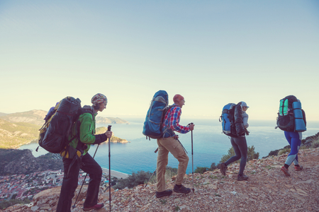
2. Gear Up: Essential Navigation Tools and Technology
When exploring the vast landscapes of US National Parks, having the right navigation gear is key to staying found. Even experienced hikers can lose their way if they’re not properly equipped. Here’s an overview of must-have navigation tools and popular brands you’ll find in packs across America.
Maps: Your First Line of Defense
Updated paper maps remain a staple for any backcountry trip. They don’t rely on batteries or signal, making them reliable in remote areas. Look for maps from trusted sources like:
| Brand/Source | Features |
|---|---|
| National Geographic Trails Illustrated | Durable, waterproof, trail-specific details |
| USGS Topographic Maps | Official government topo maps, highly detailed |
| Pocket Naturalist Guides | Pocket-sized, region-specific quick references |
Compasses: The Classic Navigator
A quality compass is essential as a backup to digital devices. Some well-known US brands include:
- SILVA: Durable and user-friendly, popular among American hikers.
- Suunto: Trusted for reliability and precision.
If you’re new to using a compass, consider taking a short orientation course at your local outdoor store or park visitor center.
GPS Devices: High-Tech Help
Handheld GPS units offer real-time location tracking, breadcrumb trails, and pre-loaded park maps. Popular options in the US include:
| Device | Main Features |
|---|---|
| Garmin GPSMAP Series | Rugged build, color display, long battery life, used by rangers and SAR teams. |
| Garmin inReach Mini/Explorer+ | Adds satellite messaging/SOS function; great for solo adventurers. |
| Magellan eXplorist Series | User-friendly interface; good mapping features. |
Pro Tip:
Always carry extra batteries or a power bank. Cold weather drains batteries faster!
Smartphone Apps: Handy but Not Foolproof
Your phone can be a powerful tool when paired with the right app. Some top picks among US hikers are:
- Gaia GPS: Offers offline maps, route planning, and trail databases tailored to US parks.
- AllTrails: User-generated trail info, reviews, and GPS tracking—ideal for day hikes and crowd-sourced updates.
- Caltopo: Advanced map layers and downloadable topo maps for offline use.
Remember, cell service is limited in many parks. Download maps before you hit the trail and don’t rely solely on your phone!
Packing Checklist: Essential Navigation Gear for US National Parks
| Item | Recommended Brands/Apps |
|---|---|
| Pocket Map (Waterproof) | National Geographic, USGS |
| Compass | SILVA, Suunto |
| GPS Device (Handheld) | Garmin, Magellan |
| Smartphone App (Offline Capable) | Gaia GPS, AllTrails, Caltopo |
| Batteries/Power Bank | Anker, Goal Zero |
| Laminated Route Notes/Itinerary Copy | N/A (make your own) |
This mix of classic tools and modern technology gives you the best shot at staying oriented in America’s wild places. Don’t just pack your gear—know how to use it before you head out!
![]()
3. Leave a Plan: Informing Others of Your Route
Before you hit the trails in any US National Park, it’s essential to let someone know your plans. This simple step can be a lifesaver if you run into trouble or get lost. Here’s how you can make sure your adventure is safe and worry-free:
Best Practices for Sharing Your Trip Details
Always leave your trip details with a trusted friend, family member, or park staff. Include the following information:
| Trip Detail | What to Include |
|---|---|
| Your Route | Main trail name, side trails, intended destinations (viewpoints, campsites) |
| Start & End Times | When you plan to begin and finish your hike or trip |
| Group Members | Full names and contact info for everyone in your group |
| Check-In Times | When you’ll check in with your contact or ranger station |
| Emergency Plan | Your steps if something goes wrong (who to call, when to alert help) |
Using Ranger Stations and Visitor Centers
Most national parks have ranger stations or visitor centers where you can register your plans. Many parks encourage hikers and backpackers to fill out a trip itinerary card before heading out. Rangers are familiar with local conditions and can give advice about current hazards or weather changes.
How to Check In and Out with Rangers
- Before your trip: Stop at the ranger station or visitor center and give them your planned route and expected return time.
- After your trip: Remember to check back in so rangers know you’ve returned safely. This helps avoid unnecessary search efforts.
- If plans change: Update the ranger station or your emergency contact as soon as possible.
Telling Multiple Contacts is Best Practice
If possible, inform both a trusted person back home and park staff about your plans. That way, if something happens, more people will know where to start looking for you.
4. Trail Etiquette and Wayfinding Skills
Tips for Following Trail Markers
Trail markers—sometimes called blazes or signs—are your best friends on any hike in a U.S. National Park. They’re usually color-coded shapes, painted marks, posts, or small signboards placed along the path. Always pay close attention to these markers and double-check at intersections to ensure you stay on the right trail. If you haven’t seen a marker for a while, stop and retrace your steps back to the last one.
Common U.S. Trail Marker Symbols
| Symbol/Color | Meaning |
|---|---|
| White rectangle | Main/official trail (like the Appalachian Trail) |
| Blue blaze | Side trail or spur route |
| Red dot or diamond | Difficult or advanced section |
| Cairns (rock piles) | Route marker in rocky or open terrain |
| Arrows/signs with names & mileage | Direction and distance information |
Reading U.S. Signage Effectively
American national parks use clear, easy-to-read signs at most trailheads and intersections. Signs often include:
- Mileage: How far it is to certain landmarks or destinations.
- Trail Names: Some trails have unique names; always know which one you’re following.
- Difficulty Ratings: Look for “Easy,” “Moderate,” or “Difficult” designations.
- Emergency Info: Some signs show emergency numbers or ranger station locations.
If you’re unsure about a sign, take a photo for reference as you hike.
Staying on Designated Paths
The golden rule of U.S. hiking: Stay on marked trails! Not only does this protect sensitive habitats and wildlife, but it also keeps you from getting lost. Cutting across switchbacks or wandering off-trail increases your risk of disorientation and can cause erosion.
- Avoid shortcuts: Even if a path looks “faster,” stick to official routes.
- If the trail splits: Use posted maps, apps like AllTrails, or ask fellow hikers which way to go.
- No visible path? Turn back immediately to where the markings are clear.
Understanding Backcountry Routes
If you venture into more remote areas, wayfinding gets trickier. Backcountry routes might not have regular markers or well-trodden paths. Here’s how to navigate safely:
- Cairns: In rocky regions, look for stacked rocks as guides—but don’t build new ones unless absolutely necessary.
- Navigational Tools: Bring a map, compass, and GPS device. Know how to use them before heading out.
- Parks’ Regulations: Some parks require permits for backcountry travel; always check in advance.
- Buddies: Hike with a partner in remote areas for added safety.
Your On-Trail Checklist
- Check for markers every 5-10 minutes.
- Photograph important signs and maps at trailheads.
- If lost: Stop, stay put, review your map/GPS, and calmly retrace your steps if safe.
- Treat all trails with respect—for your safety and the next hiker’s peace of mind!
5. What to Do If You Get Turned Around
If you realize you’re not sure where you are in a US National Park, don’t panic! Even experienced hikers can get disoriented. Here’s how to keep calm and take smart steps to find your way back.
Stay Calm and Use the STOP Method
The most important thing is to stay calm. Panicking can make things worse, so take a few deep breaths and remember the STOP method, which is widely used by park rangers and outdoor experts across the US:
| Letter | What to Do |
|---|---|
| S | Stop: As soon as you realize youre lost, stop moving. Sit down and try to relax. |
| T | Think: Take a moment to recall where you last saw a trail marker or familiar landmark. |
| O | Observe: Look around for signs, sounds, or any helpful clues like distant voices, water, or trail blazes. |
| P | Plan: Decide your next steps. Consider whether it’s safer to stay put or try retracing your steps based on what you observed. |
Contacting Park Rangers or Emergency Services
If you have cell service, use your phone wisely. Dial 911 or the park’s emergency number (often found on trailhead maps or your park map). In many US parks, texting 911 may work even when calls don’t go through. If you’re using a satellite communicator or personal locator beacon, follow device instructions for sending an SOS signal.
Helpful Info When Reaching Out for Help:
- Your location (as best as you know — look for landmarks or GPS coordinates)
- A description of your surroundings (trees, rivers, trail signs)
- Your physical condition and anyone else with you
- Any gear or supplies you have left
When to Stay Put vs. When to Move
If you’re truly lost and can’t find a safe way back, it’s usually safest to stay put and wait for help. Moving around may take you farther from the trail and make rescue harder. Only move if you’re certain about the direction and it’s safe — for example, if you spot a nearby trail marker or hear voices from a main path.