1. Origins and Evolution of GPS Technology
The story of GPS—short for Global Positioning System—begins decades ago, long before smartphones or handheld navigation devices became part of our outdoor adventures. Understanding how GPS evolved helps modern explorers appreciate the tools they now rely on in the wild.
The Military Roots of GPS
GPS started as a project by the U.S. Department of Defense during the Cold War era. The military needed a reliable way to pinpoint locations anywhere on Earth, whether for troops, ships, or aircraft. In 1978, the first experimental GPS satellite was launched, setting the stage for a system that would eventually change outdoor navigation forever.
Key Milestones in GPS Development
| Year | Milestone | Impact on Navigation |
|---|---|---|
| 1978 | First GPS satellite launched (NAVSTAR) | Paved the way for global coverage |
| 1983 | Civilian access allowed after Korean Air Lines incident | Public could start using GPS technology for safety |
| 1995 | Full constellation of 24 satellites operational | Consistent and accurate global positioning became possible |
| 2000 | Selective Availability turned off | Civilian accuracy improved dramatically—big win for hikers & adventurers! |
| 2010s+ | Integration with smartphones and wearable tech | Easy, portable navigation now in everyone’s pocket or on their wrist |
The Shift from Military to Outdoor Recreation
Once GPS was made available to the public, it quickly caught on with outdoor enthusiasts. Early adopters used bulky handheld receivers, but as technology advanced, devices became smaller, lighter, and more affordable. Now, backpackers, hunters, mountain bikers, and climbers use GPS not only to find their way but also to track routes, mark waypoints, and share adventures with friends.
How GPS Changed Wilderness Exploration in America
- No more getting lost: Reliable location data means fewer search-and-rescue emergencies.
- Route planning: Adventurers can pre-plan hikes or bike rides with precise mapping tools.
- Safety net: SOS features on modern devices help explorers call for help if needed.
- Community sharing: Sharing tracks and waypoints builds a community of outdoor lovers across the country.
The Takeaway: From Satellites to Summit Views
The evolution of GPS from military roots to essential wilderness tool has revolutionized how Americans explore their wild spaces. Whether you’re bagging peaks in Colorado or hiking the Appalachian Trail, today’s navigation tools owe everything to those early satellites and decades of innovation.
2. How GPS Works: Signals, Satellites, and Accuracy
The Science Behind GPS Functionality
When you’re out exploring the backcountry in the U.S., your GPS device is quietly performing a high-tech dance with satellites orbiting far above Earth. But how does it all work? Let’s break it down so you can trust your gear on every adventure.
How Your Device Communicates with Satellites
Your handheld GPS or smartphone isn’t just picking up a single signal—it’s listening to at least four satellites at once. Each satellite sends out a unique radio signal with its location and the exact time. Your device calculates how long each signal takes to arrive, then uses that info to pinpoint where you are on the planet. This process is called trilateration—not triangulation!—and it’s what gives you that blue dot on the map.
GPS Trilateration Explained
| Step | Description |
|---|---|
| 1. Signal Sent | Satellites broadcast their position and time. |
| 2. Signal Received | Your device receives signals from 4+ satellites. |
| 3. Distance Calculated | The device measures how long each signal took to arrive. |
| 4. Location Determined | The device uses these distances to calculate your exact spot. |
What Affects GPS Accuracy?
Most of the time, GPS is pretty accurate—usually within 10-16 feet (3-5 meters) for consumer devices. But several factors can make your readings better or worse:
| Factor | Impact on Accuracy |
|---|---|
| Trees & Mountains | Dense forests or steep canyons can block signals, causing errors. |
| Atmospheric Conditions | Ionosphere and weather can slightly delay signals. |
| # of Satellites Visible | More satellites = more precise fix; fewer means less accuracy. |
| Device Quality | Some phones and GPS units have better antennas or software than others. |
| Urban Canyons (Buildings) | Tall structures can bounce signals, leading to “multipath” errors. |
Busting Common Myths About GPS Navigation
- You don’t need cell service for GPS to work: True! GPS uses satellites, not cell towers. However, downloading maps ahead of time is a smart move if you’ll be off-grid.
- The more bars you have, the better your GPS: Not quite. “Bars” show cell signal, not satellite connections. Even if you have zero bars, your GPS can still find your location—as long as it can see the sky!
- GPS always knows your elevation: Not exactly. Horizontal position is usually spot-on, but elevation data can be less precise due to satellite geometry and other factors.
- A cloudy day ruins accuracy: Nope! Clouds don’t really affect GPS signals—but heavy tree cover or deep valleys might.
If you understand how your GPS works and what influences its performance, you’ll navigate America’s wild places with more confidence—and avoid some common missteps along the way.
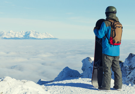
![]()
3. Comparing Navigation Tools: GPS Devices, Smartphones, and Traditional Maps
Modern wilderness explorers have more navigation options than ever before. Whether youre deep in the Rockies or trekking through the forests of the Pacific Northwest, choosing the right tool for the job is key. Lets break down the pros and cons of dedicated GPS units, smartphone apps, and classic paper maps—and see when each shines out in the wild.
GPS Devices: Rugged and Reliable
Dedicated GPS units are built for serious outdoor use. Theyre tough, waterproof, and designed to work even when your phone service drops off. Most come with long battery life and topographic maps preloaded, making them a go-to for backcountry navigation.
Pros:
- Highly accurate location tracking
- Works without cell signal
- Waterproof and impact-resistant
- Batteries often last days
Cons:
- More expensive than other options
- User interface can feel old-school
- Heavier than a phone or map
Smartphone Apps: Convenience at Your Fingertips
Smartphones are everywhere—and with mapping apps like Gaia GPS, AllTrails, or onX Backcountry, they’ve become powerful navigation tools. Download offline maps before you head out and you’ll have a wealth of info right in your pocket.
Pros:
- Easy to use and familiar interface
- Access to multiple map types and trail data
- Doubles as a camera and emergency contact device
- Lighter than carrying extra gear
Cons:
- Batteries drain quickly (especially in cold weather)
- Screens can be hard to read in bright sunlight or rain
- Fragile—easier to break or lose signal deep in the backcountry
Traditional Paper Maps: Always Reliable
Packing a paper map may seem old-fashioned, but it’s still one of the most dependable ways to navigate outdoors. No batteries required, works in any weather, and gives you a broad overview of the terrain.
Pros:
- No batteries needed—always ready to use
- Covers large areas for planning routes or finding alternate paths
- Tough to break (unless they get soaked!)
Cons:
- No real-time location tracking—you need to know how to read them!
- No built-in waypoints or track recording
- Easily damaged by water if not protected
Quick Comparison Table
| GPS Devices | Smartphones & Apps | Paper Maps | |
|---|---|---|---|
| Accuracy | High (satellite-based) | Varies (depends on device/app) | User-dependent |
| Battery Life | Long (replaceable batteries) | Shorter (recharge needed) | N/A |
| Durability | Tough, weatherproof | Fragile, water-sensitive | Tough if protected from water |
| User Friendliness | Moderate (learning curve) | High (intuitive apps) | Low (requires skills) |
When to Use Each Tool?
If youre heading into truly remote areas or expect rough conditions, a dedicated GPS device is your best friend. For day hikes or well-marked trails close to civilization, smartphones offer flexibility and ease of use. And no matter what digital tech you carry, always pack a paper map as backup—because technology can fail when you least expect it. Mixing and matching these tools gives you both confidence and safety as you explore Americas wild places.
4. Must-Have GPS Features for American Wilderness Adventures
When you’re exploring the wild spaces of America—from the Rocky Mountains to the Appalachian Trail—a reliable GPS device is your best friend. But with so many options out there, which features really matter for hikers, backpackers, and outdoor lovers? Here’s a guide to the must-have GPS features that make a difference in the American backcountry.
Essential GPS Features for Outdoor Navigation
| Feature | Why It Matters | Best For |
|---|---|---|
| Topographic Maps (Topo Maps) | Show elevation changes, terrain types, and land features—crucial for route planning and staying oriented on trails. | Hiking, Backpacking, Off-Trail Exploration |
| Waypoint Logging | Mark key spots like campsites, water sources, or trail junctions so you can easily find your way back or share locations with friends. | Day Hikes, Multi-Day Treks, Group Adventures |
| Geofencing | Create virtual boundaries; get alerts if you stray too far from your planned route—especially helpful in dense forests or open desert landscapes. | Solo Explorers, Remote Backcountry Trips |
| Emergency SOS Functionality | Send distress signals via satellite—even when you have no cell signal. This feature can connect you directly to search and rescue services. | All Wilderness Activities (Essential Safety Feature) |
The American Landscape: Unique Challenges, Smart Solutions
The U.S. offers everything from snow-capped peaks to vast deserts and thick forests. Because of this diversity, certain GPS features become extra important:
- Topo Maps: In mountainous areas like the Sierra Nevada, understanding elevation is critical for safe travel.
- Waypoint Logging: On long-distance trails such as the Pacific Crest Trail or in maze-like national parks, marking waypoints keeps you on track.
- Geofencing: In places like Yellowstone or the Grand Canyon, geofencing can alert you if you wander into hazardous zones.
- SOS: Whether youre deep in Alaska or lost in Utahs canyon country, having emergency SOS gives peace of mind to both adventurers and their families.
A Few More Handy Features to Look For:
- Long Battery Life: Essential for multi-day trips where charging isn’t possible.
- User-Friendly Interface: Big buttons and clear screens are great when you’re wearing gloves or facing bad weather.
- Weather Updates: Some GPS units offer real-time weather alerts—a lifesaver in fast-changing mountain conditions.
- Waterproof/Durable Design: U.S. adventures can mean rainstorms, river crossings, or rugged terrain. A tough device stands up to it all.
Your GPS: A True Adventure Partner
Packing a GPS with these must-have features means you’re ready to safely tackle whatever America’s great outdoors throws at you. Whether it’s a quick weekend hike or a cross-country trek, these tools help make every adventure safer and more enjoyable.
5. Best Practices and Safety Tips for Off-the-Grid Navigation
Stay Powered Up: GPS Battery Management
Nothing’s worse than having your GPS die in the middle of nowhere. Smart battery management is a must for every backcountry explorer. Here are some key ways to keep your device alive:
| Tip | Description |
|---|---|
| Turn Down Screen Brightness | Lowering screen brightness conserves energy. |
| Use Airplane Mode | If possible, turn off WiFi and cellular data to save battery. |
| Carry Extra Batteries or Power Banks | Packing a backup power source ensures you won’t be stranded if your main battery runs out. |
| Limit Unnecessary Use | Check your GPS only when needed, not constantly. |
Map Downloads: Always Plan Ahead
Cell service can be spotty or non-existent in remote areas. Download all necessary maps before heading out. Choose offline map features in your favorite navigation apps like Gaia GPS, AllTrails, or Google Maps. Double-check that you have the right area covered—don’t forget alternate routes in case plans change!
Backup Strategies: Redundancy is Key
No one should rely on just one tool in the wilderness. Here’s a quick look at essential backups for safe navigation:
| Primary Tool | Backup Option | Why It Matters |
|---|---|---|
| GPS Device/App | Pocket Compass & Paper Map | Batteries fail; physical tools never run out of power. |
| Main Smartphone App | Secondary GPS App (on another device) | Diversifies technology in case of software glitches or loss. |
| Digital Route Plan | Printed Route Notes (in waterproof bag) | If devices are lost or damaged, paper notes help keep you on track. |
Leave No Trace Navigation Ethics
Navigating responsibly means respecting both the land and other explorers. Stick to established trails whenever possible to prevent erosion and protect wildlife habitats. Avoid marking rocks or trees as waypoints—use digital markers instead. Always double-check local regulations for GPS use, especially in sensitive environments like national parks or tribal lands.
Quick Tips for Responsible Navigation:
- Do not create new trails or shortcuts.
- Avoid disturbing natural features when setting up waypoints.
- Share knowledge with fellow hikers but keep exact locations of fragile sites private to protect them from overuse.
Following these best practices will help ensure your adventures remain safe, fun, and sustainable for everyone who loves the wild places we explore.