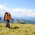
Introduction: Navigating the Unexpected
Imagine standing at the edge of a dense pine forest in the Rockies or beneath towering redwoods in Northern California, your path lost to a sudden fog or an unmarked trail. The sun dips low, shadows stretch long, and you realize—your GPS has no signal. In these moments, orienteering isn’t just a sport; it’s an essential survival skill that can mean the difference between panic and purposeful action. Whether hiking in the Appalachians, exploring the deserts of Arizona, or camping deep in Yellowstone, knowing how to navigate with a map and compass—and when to trust natural signs—becomes critical. This article sets out to explore orienteering through a distinctly American lens, drawing from the wild landscapes that shape our adventures and emergencies alike. We’ll dive into visual stories of losing your way, then finding it again through skills honed by generations of explorers, scouts, and outdoor enthusiasts. If you’ve ever wondered how to read your surroundings when technology fails, you’re in the right place.
2. Map Basics: Reading the Landscape at a Glance
Understanding a map goes beyond just knowing north from south; its about reading the story of the land. In the American backcountry, especially across vast national parks and wilderness areas, topographic maps are your main companion. These maps, often produced by the USGS (United States Geological Survey), break down elevation changes, water features, vegetation, and man-made structures with precise symbols and contour lines. The trick is translating these paper features into real-world cues you can spot on the trail. For example, tightly packed contour lines mean a steep climb—think of hiking up a ridge in Colorado’s Rockies—while wide spaces suggest gentle terrain like those rolling hills in Shenandoah.
Topographic Map Symbols Cheat Sheet
| Symbol | Meaning | Real-World Example |
|---|---|---|
| Blue Line | Stream or River | Creeks in Yosemite Valley |
| Green Shading | Forest or Heavy Vegetation | Pine woods in Oregon’s Cascades |
| Dotted Black Line | Trail/Footpath | Appalachian Trail markers |
| Brown Contour Lines | Elevation/Relief | Slope of Grand Canyon rim |
USGS References: Why They Matter
The USGS has mapped much of America with 7.5-minute quadrangles—each covering about 49 to 70 square miles—which are standard for hikers and search-and-rescue teams alike. Knowing how to read the map’s legend and scale is crucial; it helps you judge distances and estimate travel time, which is vital when daylight is fading or weather shifts unexpectedly.
Translating Paper Terrain to Real World Navigation Tips:
- Identify prominent landmarks on your map—mountain peaks, lakes, rivers—and look for them as visual anchors while you hike.
- Practice “terrain association”: match what you see around you (like a saddle between two hills) to the map’s contours and features.
- If lost, find a high vantage point to orient yourself using both compass bearings and recognizable natural features.
Navigating with a map isn’t just about following lines—it’s about letting the landscape tell its story and learning to listen. This skill can make all the difference when electronics fail or trails vanish beneath snow or brush in America’s wild places.
3. Compass Mastery: Trusting the Needle When Technology Fails
If your GPS gives up the ghost, it’s time to trust your compass—a classic backcountry essential that’s as reliable as the sunrise over the Rockies. Whether you’re wielding a traditional lensatic compass or a baseplate model favored by North American hikers, knowing how to use your tool is key to finding your way out of trouble.
Getting to Know Your Compass
First things first: The needle always points north—but not necessarily “true” north. Most of the U.S. sits east or west of the magnetic north pole, which means you’ll need to factor in magnetic declination. Check your local map legend for this info; in places like Seattle, you might adjust 15 degrees east, while on the Appalachian Trail, it could be just a few degrees. Adjust your compass housing accordingly so your navigation stays accurate, whether you’re bushwhacking in the Sierras or following a marked trail in the Adirondacks.
Traditional vs. Baseplate Compasses
A lensatic compass is rugged—military style and perfect for shooting bearings over long distances (think crossing open prairies). The baseplate, meanwhile, is a favorite for hikers and search-and-rescue crews because it lays flat on your map, letting you draw lines between where you are and where you want to be. In American hiking slang, you might hear folks say “shoot an azimuth” (meaning take a bearing) or “walk a line,” referring to following a set direction across country.
Quick Steps for Accurate Navigation
1. Lay your map flat and align your baseplate compass along your intended route.
2. Rotate the bezel until orienting lines match north on your map—don’t forget declination!
3. Hold steady and turn until the red needle matches the orienting arrow (“put red in the shed,” as some guides say).
4. Move forward, keeping an eye out for natural landmarks—like bluffs or old logging roads—that confirm your path.
In emergencies, when cell signals fade and batteries die, compass mastery is what separates seasoned outdoor folks from those who get turned around at dusk. Trust the needle—and your own skill—to guide you home under big American skies.
4. Natural Navigation: Letting the Wild Guide You
When technology fails or traditional tools are lost, nature itself becomes your compass. Visual cues in the American wilderness offer a lifeline for orientation, especially when you know what to look for. The silhouettes of distant mountain ranges, the path of the sun across the sky, and even patterns in familiar flora can guide your way with surprising accuracy.
Mountain Silhouettes: America’s Landmarks
The United States is home to iconic mountain ranges like the Rockies, Appalachians, and Sierra Nevada. Each has a distinct profile that locals often use as navigational reference points. For example, in Colorado, the sharp outline of Longs Peak stands sentinel over the Front Range, while Mount Rainier’s solitary dome dominates Washington’s horizon. Recognizing these shapes and knowing their relative position can help you keep your bearings if you stray from marked trails.
Sun Paths: Reading Time and Direction
The sun’s arc provides reliable directional cues, especially in open country. In North America, remember:
| Time | Sun Position | Direction (Facing Sun) |
|---|---|---|
| Morning (around 7-9 AM) | Rising | East |
| Noon (around 12 PM) | Highest point | South (in Northern Hemisphere) |
| Evening (around 5-7 PM) | Setting | West |
This method works best when paired with other landmarks or natural indicators for confirmation.
Landmarks and Flora: America’s Natural Signposts
In many U.S. regions, local flora acts as a subtle guidepost. Moss tends to grow on the north side of trees in northern states due to limited sunlight, though this rule isn’t universal—use it with caution and in combination with other signs. In deserts like Arizona or New Mexico, saguaro cacti often lean slightly southward due to sun exposure. Prairie grass typically grows taller on the leeward side of prevailing winds—usually from the west in much of the Midwest.
Common U.S. Orientation Cues Table
| Cue Type | Example/Region | Navigational Insight |
|---|---|---|
| Mountain Ranges | Sierra Nevada (California) | West boundary; follow range for latitude alignment |
| Trees/Moss Growth | Northern Pines (Minnesota) | Moss thicker on north-facing bark (with exceptions) |
| Cactus Lean | Saguaro (Arizona) | Cacti lean subtly south due to sunlight patterns |
| Prairie Grass Height | Kansas Tallgrass Prairie | Taller on east side, indicating westerly wind origins |
The Art of Observation in Emergency Orienteering
Cultivating awareness of these visual cues transforms any outdoor setting into a living map. Practice reading your environment before emergencies strike; over time, natures signals become as clear as any printed chart or digital display.
5. Orienteering in Action: Real-life American Survival Stories
Across the sweeping landscapes of the United States, stories of survival unfold where orienteering skills become a lifeline. These short, vivid accounts spotlight hikers, hunters, and campers who navigated emergencies by trusting their map, compass, and instincts.
Lost in the Rockies: A Hiker’s Quick Thinking
When Sarah, an avid hiker from Colorado, lost her trail during a sudden snowstorm in Rocky Mountain National Park, GPS signals faded into static. Instead of panic, she unfolded her topographic map and set her compass to true north. Guided by familiar ridgelines and the sound of a distant stream—her “natural compass”—Sarah retraced her steps to safety, proving that analog skills still reign when technology fails.
Hunters in the Ozarks: Reading Nature’s Signs
Deep in Arkansas’ Ozark forests, two hunters found themselves separated from their group as dense fog rolled in. Drawing on years of experience, they relied on their compass bearings and paid close attention to subtle cues—the slope of the land, moss growth on tree trunks, and distant bird calls. By cross-referencing these signs with their map, they navigated back to camp before nightfall.
Campers in Yosemite: Following Waterways Home
A family camping trip turned tense when dusk fell faster than expected in Yosemite Valley. Without cell service or marked trails nearby, the group remembered their guide’s advice: “Waterways always lead somewhere.” Using a simple compass bearing and following the river downstream while checking landmarks on their waterproof map, they safely found their way to a ranger station as darkness settled over the Sierras.
The Power of Preparation
These real-world American stories echo a clear lesson—preparation and practice with basic orienteering tools can make all the difference when things go sideways outdoors. Whether you’re navigating vast wilderness or local woodlands, knowing how to read a map, use a compass, and trust nature’s clues transforms daunting emergencies into manageable challenges.
6. Practicing Skills: Making Orienteering Second Nature
If you want to make orienteering a reliable skill in an emergency, practice is everything. Luckily, there are plenty of easy ways and community resources across the U.S. to help you sharpen your navigation abilities before you ever find yourself in a pinch.
Easy Exercises for Every Level
You don’t have to trek deep into the backcountry to start building your orienteering chops. Begin with simple backyard drills: try setting up waypoints using everyday landmarks—like a tree, mailbox, or fence post—and navigate between them using only your map and compass. Gradually increase difficulty by removing familiar reference points or timing yourself as you plot a course from one end of a local park to another.
Joining Orienteering Clubs
Across the States, orienteering clubs offer structured opportunities to learn, practice, and compete. These clubs are welcoming to all experience levels and often host beginner-friendly clinics. The U.S. Orienteering Federation (USOF) lists active clubs from the Pacific Northwest’s mossy forests to the rolling Appalachian hills. Local clubs not only provide access to maps and equipment but also connect you with experienced navigators who love sharing tips—think of it as a trail family ready to help you grow.
Community Events and Trail Systems
Many state parks and recreation areas have permanent orienteering courses set up for public use—perfect for solo practice or group outings. Events like “map hikes,” night navigation races, and family scavenger hunts are common throughout spring and fall across America’s extensive trail systems—from Minnesota’s Northwoods to the foothills of California’s Sierras. These gatherings aren’t just about honing skills; they’re celebrations of outdoor adventure and resilience, complete with campfire stories and shared triumphs over tricky terrain.
Whether you’re plotting a course through urban greenways or exploring remote wilderness trails, making orienteering second nature comes down to regular practice—and enjoying every step along the way with others who share your passion for maps, compasses, and wild horizons.
7. Conclusion: Confidence in the Wild
When you step into the vast American backcountry, confidence is your greatest ally. Whether you’re navigating the rugged Rockies, wandering beneath the ancient pines of Appalachia, or tracing a desert trail in the Southwest, your map and compass are more than just tools—they are lifelines that connect you to the land’s story and your own survival. Trusting your instincts doesn’t mean ignoring these resources; it means blending your natural intuition with time-honored orienteering skills. In those moments when technology fails or trails vanish, let your senses guide you as much as your compass needle. Remember: every successful trekker, search-and-rescue member, and seasoned scout has learned that nature rewards respect and preparation. So as you shoulder your pack and face the horizon, take pride in mastering these timeless skills—because out here, self-reliance isn’t just tradition; it’s part of the American spirit.